A “pioneering” British tech startup, Yeme Tech, aims to improve urban planning for towns and cities by helping councils and developers to better respond to local needs for community facilities, spaces and events.
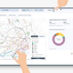
Inspired by Lord Mawson’s work at the nationally renowned Bromley by Bow Centre, Yeme Tech, has created a highly sophisticated Community Data Platform (CDP) to help planners and developers instantly identify social infrastructure, facilities, and community spaces which are missing from British neighbourhoods.
The platform is the result of years of work by the Yeme Tech team including its Founder and CEO Amir Hussain, who is Deputy Chair of Housing Regeneration and Place at West Yorkshire Combined Authority.
Amir believes the Community Data Platform will create happier, healthier and more engaged neighbourhoods by empowering councils and developers to identify facilities and events which residents actually need and will frequent.
Now Yeme Tech, based in Bradford, plans to take this approach global after signing a partnership deal with Esri UK, part of the world’s largest provider of geographic information system (GIS) software Esri Inc.
Esri UK’s customers include HS2, Sustrans, Sport England, National Trust, The Environment Agency, Ordnance Survey, Greater London Authority and more than 200 local authorities in England and Wales.
Esri Inc, headquartered in San Bernardino in California, is used by more than 30,000 cities and local councils, 12,000 national government agencies, 33,000 businesses and 12,000 not-for-profits.
Instead of imposing top-down solutions on neighbourhoods the platform is layered with granular insights about communities to help planners and developers cultivate and manage long-term relationships with the people who have the largest stake in the success of a neighbourhood — the local residents.
Amir said the platform not only measures community resources — such as schools, shops, green space, libraries and cultural assets — but also local stakeholders, local events and the activities of local groups.
This gives a far more holistic view of the social as well as economic health of communities. It can cross-reference this data with demographic information to better judge whether local needs are being satisfied and, crucially, whether there are any gaps in provision.
This enables planners and developers to make sure new property and social interventions deliver inclusive growth for marginalised and hard-to-reach community groups. It also helps to create more integrated and fulfilling places for everyone.
With the importance of social value now a key business consideration, the platform’s ESG Social Reporting Index helps developers, investors and others to target and evidence social uplift around their assets or development sites.
 Amir (pictured right) said: “Society has changed beyond all recognition over the past 30 years.
“The failure of places to keep pace with change is understandable but means towns and cities across the UK, like those across the world, have lost track of the needs and wants of local people. This leads to places losing their sense of identity while loneliness, exclusion and community fragmentation are having profound impacts on health and wellbeing.
“The death of retail and the High Street offers councils and developers a bold opportunity to reinvent their neighbourhoods by strengthening existing social and community assets and strengthening relationships with local stakeholders.
“It can be very complex and time-consuming to regenerate our towns and cities to adapt to meet the current and future needs and wants of their citizens.
“What our Community Data Platform does is provide granular local detail in real-time to strip away the complexity and enable planners and developers to work with local communities to deliver successful urban planning which provides the facilities and social infrastructure that people need and want.”
The Bromley by Bow Centre was the first integrated health centre in Britain and included community support, business support, housing support, an art gallery, and an events venue.
Its doctors offer patients more than drugs — they are able to prescribe activities, including art courses, access to community care, and an allotment. This approach is now being delivered nationally in a series of Innovation Projects by Well North Enterprises.
Lord Andrew Mawson OBE, Director of Andrew Mawson Partnerships and President of the Bromley by Bow Centre, said: “Supporting people, helping them to identify opportunities and empowering them to take up those opportunities is how the Bromley By Bow Centre works.
“Yeme Tech takes those principles and provides data insight to help planners and developers to identify opportunities which will transform our towns and cities and their inhabitants.
“Yeme Tech is pioneering a different way of doing things — informed by the work we have been doing over the past 40 years — by enabling cities to be planned for the benefit of people and developed in co-operation with communities based on the data insights of what the people actually need.
“One day all cities will be planned like this and we will wonder why the Community Data Platform did not exist sooner.”
Laura Dean, Esri Partner Network Manager, commented: “Esri UK is delighted that Yeme Tech has joined our Esri Partner Network. Making use of our suite of developer tools, ArcGIS Developers, the team has managed to represent community data in a clear and engaging manner, allowing users to achieve valuable new insights. We look forward to working closely with the Yeme Tech team moving forward.”